


les arcs sur argens

chrifor
User
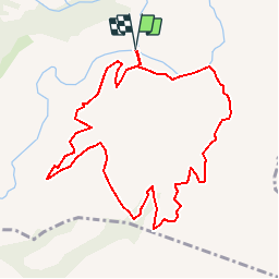

Length
10.8 km

Max alt
333 m

Uphill gradient
353 m
Km-Effort
15.5 km

Min alt
28 m

Downhill gradient
354 m
Boucle
Yes
Creation date :
2019-04-09 09:52:28.386
Updated on :
2019-04-09 09:52:28.421
3h21
Difficulty : Easy

FREE GPS app for hiking
 SityTrail
IGN / Geographical institutes
SityTrail Plus
The world is yours!
About
Trail Walking of 10.8 km to be discovered at Provence-Alpes-Côte d'Azur, Var, Les Arcs-sur-Argens. This trail is proposed by chrifor.
Positioning
Country:
France
Region :
Provence-Alpes-Côte d'Azur
Department/Province :
Var
Municipality :
Les Arcs-sur-Argens
Location:
Unknown
Start:(Dec)
Start:(UTM)
298521 ; 4811808 (32T) N.
Comments